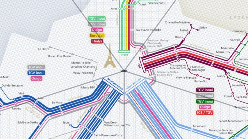
This high-speed rail map is my first non-octolinear transit map. The highly centralised high-speed rail network is the perfect occasion to escape the 45° angle structure. Instead, the network map is divided into five sectors surrounding Paris. In each sector, there is a central ray and an orthogonal axis to it. In addition, there are two rays in a 36° / 54° arrangement in each sector. They are not positioned at 45° to reflect the Paris-oriented network layout. Apart from the angle structure, the design is similar to my other maps.
The poorly systemised timetables are a huge challenge in order to combine and count the various trains. On some routes, the number of trains varies greatly between weekdays and weekends. I have tried my best to carefully check and generalise the number of trains. However, there may be some mistakes in terms of content or language. If you see any, please feel free to report them in the comments, via email or mastodon.
Please note: This is an updated version of the previous 2022 map. It is no longer online, because it contained some minor errors.
If you are interested in the official map, you will find it here. Please make also sure to have a look at the newer 2024 version of this map.

Hi, wonderful map.
FYI Thalys has just been rebranded into Eurostar: https://www.eurostar.com/
LikeLike
Thanks! I will change that for the 2024 version! Unfortunately, it means that one colour will disappear from my map.
LikeLike
you could (and it would be appropriate) use the colour for the TGV Lyria service group
LikeLike
Hey
Wonderful map, the pentagonal grid works beautifully, it mimics the 5-main-station situation in Paris, which is relevant since France’s rail network is heavily centralized.
One minor quibble about Vitré station near Britanny: your map seems to suggest that most TGVs just don’t call at that station, while in reality it located on the regular line, and not on the high speed line that now extends from Le Mans to Rennes and that’s located far away from Vitré !
LikeLike
Hey, thank you. I had to simplify the lines from Paris to Rennes and Bordeaux. There are just too many different combinations of served stations for creating a readable map. So, I neglected showing the different routes on the high-speed and the old line. Unfortunately, as a consequence, you cannot see the difference between trains running on the high-speed line and trains running on the old line without calling at a specific station.
LikeLike
While I think it’s an interesting approach – and it certainly does look good – I also think you’ve missed an occasion. In France, people often refer to the country as „the Hexagon“, on account of continental France havin a roughly hexagonal shape. So, instead of the pentagonal base, a hexagonal one might have been interesting, sort of natural.
Anyway, interesting page you have here 😉
LikeLike
Hi. Not to be that kind of guy, but
1. There are 7 major TGV stations in Paris, so it could kind of be more normal to make it a heptagon, and
2. Even if it was a hexagon, that would mean a station would have to be removed from the map.
HOWEVER, I do think it might be possible, by making Gare de Paris Bercy and Gare d’Austerlitz both only take up one side of the hexagon, since these are the least visited stations. So maybe the 2024 map could, in fact, have this?
LikeLike